Revised 02/18/2026
Marin County Hang Gliding Association (MCHGA)
Mt Tamalpais Site Description / Location
Mt. Tamalpais, located north of San Francisco between Mill Valley & Stinson Beach, is one of the most scenic mountain sites in California. (See map and driving instructions, below.) It has unobstructed panoramic views of the Pacific ocean, San Francisco, and the Bay and Delta waters. There are many popular hiking trails all around the mountain and Stinson Beach is below. The site is rated INTERMEDIATE (H3/P3) for both hang gliding and paragliding.
Because our sport is self-regulated, all pilots are responsible for obeying and enforcing the Mt Tam Flight Rules and Procedures. shown below.
The Marin County Hang Gliding Association (MCHGA) maintains Special Use permits with State and County agencies, to allow hang gliding and paragliding activities on the west side of Mt. Tamalpais, along Bolinas Ridge. There are three launch sites facing generally south to west, all at about 2000 ft. MSL. All three launch sites are rated H3/P3. (See the table below for details on acceptable wind velocities and directions for each launch.)
|
Launch site |
Wind Velocity (mph) |
Launch site |
Wind Direction (degrees) |
||||||
|
craft |
min |
ideal |
max |
gust |
min |
max |
|||
|
A |
hg |
0 |
20 |
25 |
5 |
A |
ideal |
170 |
180 |
|
pg |
0 |
15 |
15 |
5 |
ok |
155 |
190 |
||
|
B |
both |
0 |
10 |
15 |
5 |
B |
ideal |
260 |
270 |
|
|
|
|
|
|
ok |
225 |
300 |
||
|
C |
both |
0 |
10 |
15 |
5 |
C |
ideal |
265 |
275 |
|
|
|
|
|
|
ok |
240 |
310 |
||
Wind table summary: Launch A faces south; Launches B & C face west. Launching in no wind is common. Pilots generally don't fly in West winds over 15 mph or South winds over 25 mph, because of turbulence.
Weather conditions: The best season for Mt. Tam is during Winter & Spring, as the storms bring instability for good soaring conditions. In light winds, Mt. Tam is a very forgiving flying site. However, multiple ridges criss-cross the flying area between the launch and landing sites. This usually results in turbulent conditions whenever the wind velocity is over 15 mph. This can be especially challenging for paraglider pilots.
In post-frontal conditions, the wind frequently turns to NW at Tam. Pilots should be aware that there is a persistent rotor that sets up at "B" Launch in NW winds, as described below:
Below is a satellite photo of a section of Bolinas Ridge and Stinson Beach. The white line running diagonally down the upper right corner is W. Ridgecrest Blvd., which follows along the crest of Bolinas Ridge.
When we have NW winds (pictured by the blue arrows) flowing along Bolinas Ridge, the wind gets forced out and around (as well as up and over) Ballou Point. At B Launch, this creates a rotor that can sometimes result in a West wind at launch. This apparent west wind has fooled many pilots into launching into the rotor.
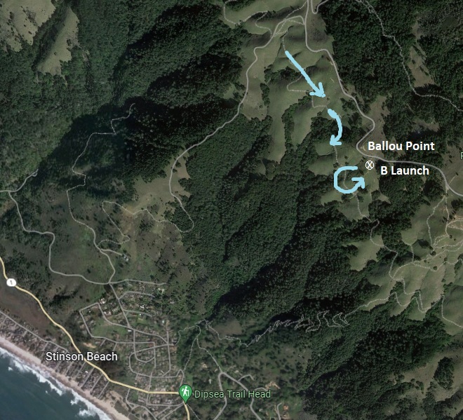
But regardless of the apparent direction at launch, NW winds are likely to produce a rotor, just off B Launch, as shown with the arrows. It is not possible to avoid this rotor from launch, except by timing your launch when this wind condition doesn't exist.
This rotor can be quite severe at times. It can potentially cause a sudden loss of control, or a full sail collapse at low altitude. Please use caution and be sure you know the true wind direction when you are launching.
Strong wind gradients are also possible, with winds dropping abruptly to zero at the beach. Reverse wind gradients are also common, and can be identified by whitecaps on the water when the wind at launch is light. Be aware that whitecaps on the ocean may also indicate that stronger winds are coming. This can create adverse conditions for paraglider pilots.
Our landing zone is on the beach, near the north end of the Stinson Beach area. The landing strip is 3,400 feet long (over one kilometer, about 0.64 miles.) On average tides, it is about 40 to 50 yards wide (the width of 4 hang gliders parked side-by-side). On most days, the beach is nearly empty, but on warm weekends or holidays it may get crowded. Check the Tide Table for high tides, especially during the winter & spring. The tide table will show you the relative tides for the day. Notice that there is no absolute tide level that is safe for landings. This is because the sand level on our beach can vary drastically from season to season. In the winter, the sand may wash away, and the beach could be flooded even on a low tide. In the summer, if the sand returns, there may be plenty of beach even on a high tide. The beach is visible from B launch, so check how wide it is and whether it is crowded, and be aware of whether the tide is coming in or going out.
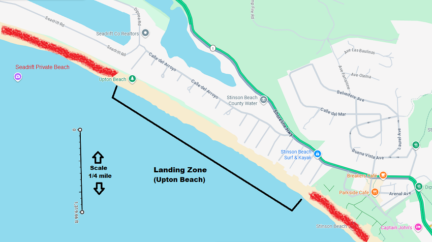
Landing Field Hazards: Normally, there is a 10 ft. high metal sign placed about 30 ft. from the alleyway in the middle of the beach. This is just beyond the (otherwise) most desireable spot to land. Be aware! This sign marks the boundary with the Seadrift private beach. Please land to the south of it.
The beach where we land may sometimes be used by people walking, sitting, flying kites, or kiteboarding. These activities create temporary, sometimes moving obstacles to our landing. This problem can be exacerbated when the beach is narrow because of the tide. Even though it is more desireable to land near the north end of our LZ, this is often the first area to get crowded. There is usually more open space for landing in the southern part of the LZ. Please be alert and find a safe place to land at least 30 feet from other beach users.
Ratings and requirements: A rating of at least H3 or P3 (intermediate) is required to obtain a sticker to fly the site. All pilots are required to get a site intro before their first flight at Tam. Site intros can be obtained only from club officers, administrators, sponsors and instructors. A good site intro should cover the following topics:
- Information about how, when and where to sign in. A visit to the Pantoll ranger station may be advisable to begin this discussion.
- A tour of all three launch sites, including a discussion of wind conditions for each site.
- A good view of the LZ, with north and south end points clearly indicated.
- A discussion of where public beach access is available.
- A description of normal flight paths, including where flying is allowed, and where the airspace is restricted.
- Information about where thermals and/or soaring is likely. Warnings about where turbulence and sink is likely.
- Advice about potential wind conditions, including gradients and turbulence. A discussion of where and when rotors are likely.
- A discussion of favorable and unfavorable weather conditions.
- A discussion of relevant rules, including a recommendation that pilots on the beach assist the landings of others.
- For newer pilots, a discussion of beach landing approaches and techniques.
______________________
* Current approved paragliding sponsors:
Anthony Abate,
Lionel Marks,
David Beerman,
Eric Beckman,
and
Andrew Whitehill.
FLIGHT INSTRUCTORS: If you have a USHPA appointment as a Basic, Advanced or Tandem instructor, you must be aware of the following restrictions:
- The MCHGA permit allows non-commercial flying, only. If you are considered a commercial instructor, you are not allowed to bring your students to fly at Tam, regardless of whether or not you will be providing instruction at the time.
- You are considered a commercial instructor if you have accepted any form of compensation for flight instruction within the past 12 months. This includes tips, gifts, donations and profits from gear sales.
- To be considered "non-commercial," the instructor must be a Rogallo member of USHPA and be Certified Non-Commercial (CNC).
- By definition, all tandem flights are for training purposes; no recreational tandems are permitted by the FAA.
- Non-commercial tandem flights are allowed for properly rated instructors and students, as long as all USHPA and FAA rules are strictly followed.
- Non-commercial instruction of H2 pilots is permitted only for club-approved instructors**, with procedures described below, in the Mt Tam Flight Rules and Procedures.
______________________
** Current approved non-commercial certified instructors: Kurtis Carter,
Takeo Eda and
Jeremy Spiegel.
GPS Coordinates for Mt. Tam:
Click on the coordinates to jump to that spot on Google Maps:| Launch Area | parking turnout | Launch point |
| A | 37.9096, -122.62 | 37.907204, -122.620107 |
| B | 37.9112, -122.6245 | 37.910665, -122.624995 |
| C | 37.920947, -122.631241 | 37.920838, -122.63266 |
| parking turnout | ||
| Landing Area | 37.9039, -122.6519 | |
| north boundary | south boundary | optimal spot |
| 37.902929, -122.653473 | 37.897920, -122.643539 | 37.902739, -122.653067 |
Mt. Tam Flight Rules and Procedures
The Marin County Hang Gliding Association (MCHGA) is designated by California State Parks and the County of Marin Department of Open Space through special use permits to administer recreational hang gliding and paragliding activities on Mt. Tamalpais (Mt. Tam). All commercial activities are forbidden under these permits. Each pilot flying this site is expected to uphold and enforce these rules. Any pilot errors made while flying, such as endangering other pilots or spectators or destruction of government or private property, could result in revocation of the County or State use permits, with potential loss of Mt. Tam as a flying site.
- PILOT QUALIFICATIONS
- All pilots must be current members of the United States Hang Gliding & Paragliding Association (USHPA) and have appropriate ratings.
- All pilots must agree to follow these rules.
- All pilots must fly with an airworthy glider, harness, and gear, including a safety helmet and reserve parachute.
- All hang glider (HG) pilots must possess a minimum of USHPA Intermediate (H3) level rating, or a USHPA Novice (H2) level rating and be accompanied by a MCHGA-approved Mt. Tam Instructor. (see: 7. HG Novice Procedures, below.)
- All paraglider (PG) pilots must possess a minimum of USHPA Advanced (P4) rating or Intermediate (P3) with completed sponsor sign-off form. A list of authorized sponsors can be found on our Pilots and Stickers page.
- All pilots must have a current Mt. Tam sticker in their possession and be able and willing to present that sticker to anyone who asks to see it. It is strongly recommended that pilots attach the sticker on the left side of their helmet to help identify qualified pilots to Park authorities and other pilots.
- To obtain a sticker, qualified pilots should follow the detailed instructions found on our Pilots and Stickers page.
- PILOT RESPONSIBILITIES
- Pilots must comply with all State Park and County Beach regulations governing visitor use (parking, littering, overnight camping, etc.)
- Pilots are responsible for their own safety and the safety of other pilots and spectators. Each pilot is ultimately responsible for avoiding people in the landing area.
- Good judgment is a necessary part of all aviation activities. It requires a thorough knowledge of the limitations of your aircraft, your abilities, and the prevailing conditions (such as sufficient altitude and penetration to cross the houses, etc., and whether your chosen landing zone is dangerously crowded). When deciding whether or not to fly, take all things into consideration.
- Because our sport is self-regulated, it is every pilot's responsibility to uphold and enforce these rules in cooperation with Park Rangers. Any pilot observing another pilot who is in violation of these rules should inform that pilot of the nature of the violation, and then request compliance. If unsuccessful in gaining compliance, politely inform the pilot that you are obligated to report them to a Park Ranger and club officers. Rangers can be contacted at Pan Toll at (415) 388-2070 or Ranger Dispatch at (916) 358-1300. Also make a verbal report to a club officer.
- Any pilot violating these rules or witnessing a violation without intervening:
- may be issued a citation by Park Rangers
- may be subject to suspension or revocation of flying privileges at Mt Tam
- risks losing their USHPA rating
- risks getting the flying site closed
- BEFORE FLYING
- Pilots who are new to the site must receive a site intro from a club officer or other authorized pilot before their first flight at Mt. Tam. For a list of authorized pilots, see our Pilots and Stickers page.
- All pilots must sign-in with the rangers prior to their first flight of the day. Sign-ins can be conducted online through this link: mchga.org/signin. Alternately, pilots may opt to sign-in on paper using the sign-in box outside the Pantoll Ranger Station kiosk.
- Be sure you know the current status of the LZ. How wide is it? How crowded? Is the tide coming or going? etc.
- When setting up, pilots should be considerate of others who are also setting up or waiting their turn to set up. When others are waiting and conditions are safe and consistently launchable, pilots who are ready should launch within 15 minutes of completing their set up procedure.
- LAUNCHING
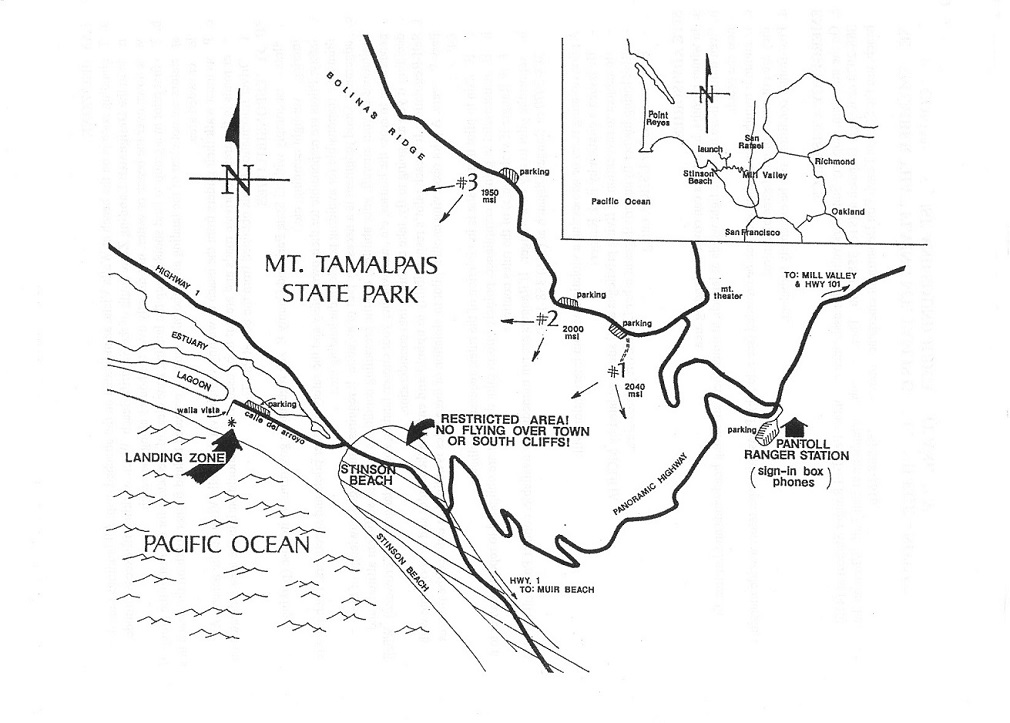
- The three designated take-off sites are shown on the attached map as 1, 2, and 3. Launching is allowed only from these sites. Specific GPS coordinates can be found on our site guide. All launches should be witnessed for safety.
- PG pilots should not launch when winds are in excess of 15 mph at launch. HG pilots should have an Advanced rated pilot present when winds exceed 15 mph at launch for flying to continue.
- When launching, pilots shall ensure that spectators remain clear of the area 30' behind, 50' in front of, and 30 degrees to the sides of the intended launch path/course.
- Launching from the back (north or east-facing) side of any launch site is prohibited.
- FLYING
- The Restricted Flying Area, indicated on the attached map, must be observed. Do not fly over the town or cliffs south of the town. Infractions may result in being ticketed and fined by CA State Parks and/or CA Highway Patrol.
- There is to be no flying when the landing zone is not visible from launch, or when the cloud ceiling is dangerously low.
- There is to be no flying when the landing area is crowded with people (which often happens on warm days or holiday weekends.) The flying site may be closed at the discretion of any State Park Ranger or club officer. However, even if the site has not been closed, no one is allowed to fly if the landing area is too crowded.
- Motorized/powered flying is strictly forbidden.
- Mini wings and speed wings are currently prohibited from flying at Mt Tam.
- No glider shall be flown in any manner which intentionally exceeds its manufacturer's maximum recommended (placard) limits.
- No pilot shall intentionally exceed a roll angle of 60 degrees or a pitch angle of +/-30 degrees while west of Highway 1.
- Pilots must head out to the landing zone with enough altitude to ensure at least 100' of clearance over the houses along the beach. Watch for changes to wind speed on the ocean as a predictor of ability to penetrate to the beach for a safe landing.
- LANDING ZONE
- The landing zone is on the beach at or south of Walla Vista, as indicated on the attached map. All landings must be made south of the Seadrift Beach and north of GGNRA's Stinson Beach Park. When working off excess altitude, do so over the beach or water and not over the houses along the beach.
- The first pilot in a group to land should attempt to keep the landing zone clear of spectators for the rest of the group. If beach users are in the landing area, pilots must be prepared to land further south on the beach in a less crowded area.
- Pilots should fold and remove their gliders from the LZ as quickly as practical.
- Pilots must exit the beach via the Walla Vista public access. All other roads in the area are for home owners/renters only and are not to be used.
- Retrieve vehicles should park along Calle del Arroyo in the area south of the Walla Vista alleyway.
- HG NOVICE PROCEDURES
Mt. Tam is the ideal place for Novice HG pilots to gain high-altitude experience.
- Novice HG pilots must meet the qualifications described above in items 1.a-c.
- Prerequisites:
The Novice pilot must either:
- be at least half way to their H3 (15 flight days, 45 Flights, 5 hrs of flight), or
- have completed 10 high-altitude flights from one or more other mountain sites
- Novice pilots must complete an Application / Waiver and pay a novice card fee. Novice cards must be in novice pilot's possession when flying Mt. Tam. More details on obtaining a Novice Card can be found on our Pilots and Stickers page.
- Prior to a Novice's first flight, the Instructor shall review these rules with the Novice pilot and provide a standard site intro.
- Both Instructor and Novice pilots must sign in prior to each day of flying.
- Instructor shall discuss with Novice the weather conditions, flightpath, etc. for the chosen launch prior to each flight. Novice pilot should launch before Instructor, and ideally following another pilot.
- Instructor shall debrief the Novice following each flight, and suggest any improvement(s) in either flight plan or execution as needed.
- Limitations:
- Novice pilots must be under the supervision of a MCHGA-approved Tam Instructor when flying at Tam.
- Novice pilots are not allowed to fly Tam on holidays or weekends.
- There can be only one Novice pilot in the air at a time.
- Instructor shall maintain radio communication with Novice while Novice is flying.
- TAM INSTRUCTOR QUALIFICATIONS:
In order to bring H2 students to Tam, instructors must receive an appointment as "Tam Instructor" as follows:
- All instructors must be a current USHPA-certified Advanced Instructor with at least 2 years experience as an advanced instructor and be approved by the MCHGA Mt. Tam Committee.
- All instructors must be Rogallo members of USHPA, and be Certified Non-Commercial (CNC).
- Instructors may not accept compensation of any form for their activities at Mt. Tam.
- Instructors wishing to apply should contact MCHGA for an application. Approval of any Mt Tam Instructor will be based on their previous flying experience at Mt. Tam, and/or recommendations(s) to the Mt. Tam Committee from applicant's former Instructors.
- SITE ADVISORIES
- High tides and especially King tides can completely cover the landing area and create dangerous risk of being caught in breaking waves. Do not fly if the beach is too narrow.
- Even though there might be light winds at launch, there can be strong headwinds and laminar flow near the beach. Always look for wind lines on the water before and during flights from Mt Tam.
- In northwest winds, Site #2 sits right behind a rotor. This rotor can sometimes produce a west wind at launch. Even though this appears to be a good direction at launch, you will be launching into a rotor.
- At times, the landing area can become crowded (see section 5.c.). Pilots must give other beach users a wide margin, as they are sometimes totally unaware of our landing approach.
- Post-frontal conditions can be extremely turbulent, especially at higher wind speeds.
- EMERGENCY ASSISTANCE
On the mountain, stop any State Park vehicle for assistance or contact Pantoll Ranger Station at (415) 388-2070 or Ranger Dispatch at (916) 358-1300. When on the beach, use the Stinson Beach Fire Department emergency number, (415) 868-1616.
PLEASE REMEMBER THAT FLYING MT. TAM IS OUR PRIVILEGE -- NOT OUR RIGHT.
USE COMMON SENSE AND SOUND JUDGMENT AND FLY SAFELY.
GOOD LIFT!
Old-fashioned Driving Instructions
From Hwy 101 in Mill Valley, take the "Stinson Beach / Hwy 1" exit. Follow Shoreline Hwy and Hwy 1 about 1/2 mile to Tam Junction, where they will turn left at the traffic signal. Continue west on Hwy 1 for 2.7 miles. Then, look for the sign which directs you to turn right onto Panoramic Hwy for Mt Tam and Muir Woods. About 0.8 miles up Panoramic, you will come to a wide intersection shaped like a crooked pitchfork. Select the middle fork to continue across on Panoramic. Follow Panoramic for another 4.4 miles to its highest point. On your left, you will see the Pantoll Ranger Station, and on the right will be Pantoll Rd. Ahead of you, the highway will begin dropping down to Stinson Beach and the LZ. Pilots must sign in at the ranger station before flying.
To reach launch, take Pantoll Rd 1.4 miles to its end, at Rock Spring. Turn left onto W. Ridgecrest Blvd. From this point, "A" launch (not visible from the road) will be 0.4 miles up the road. "B" launch, which is plainly visible, right next to the road, is just 0.3 miles further. And "C" launch is 0.9 miles beyond that.
Driving Map:
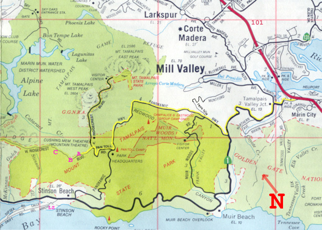
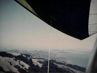
Mt. Tamalpais Photo archive
 A Launch looking S to SF A Launch looking S to SF | 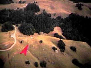 B Launch at Mt. Tam B Launch at Mt. Tam |
 C Launch at Mt. Tam C Launch at Mt. Tam | 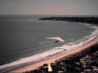 LZ at Stinson Beach LZ at Stinson Beach |
 Tam looking to SF Tam looking to SF | 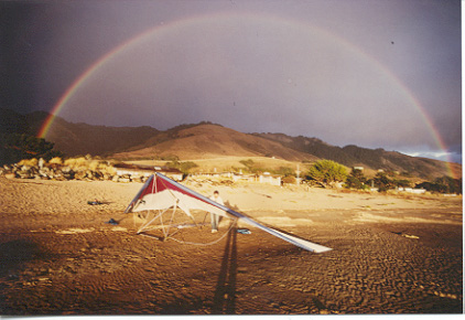 Rainbow at Stinson Rainbow at Stinson |
Copyright © 2002-2026 Marin County Hang Gliding Association, Inc.